First impressions from a tour of the areas affected by earthquakes in central Italy in 24816 and 301016
introduction
The descriptions and evaluations in the summary below are written based on initial impressions from two tours conducted separately by engineers from our office, on 10/25 and 11/1, and a preliminary review of vibration fluctuation data, as recorded at the two stations near the epicenters. They do not pretend to be a scientific article.
The descriptions and assessments are only valid for these earthquakes because the intensity, the depth of the source, the conditions of the mountainous terrain, the rocky ground and other parameters of the aforementioned earthquakes affect the specific response of the soil and structures to earthquakes, and reduce the relevance of the insights that can be produced to another region.
Despite the reservation, in our estimation it is possible to explain the three phenomena described below, as well as to understand additional phenomena described below, to draw lessons, and to improve the anti-seismic planning and the upgrade response in Israel.
Our entry into the area was made possible after receiving permission to move in the closed areas and escorted by the Italian Ministry of Civil Defense. The approval was obtained with the help of our colleagues from Italy: prof. G.M Calvi from the University of Pavia and Fuchs Renato from the Eucenter Laboratory, and we thank them for this.
References and comments are welcome.
Introduction - the earthquake on 24.8.16 and key questions
An earthquake with a magnitude of M6.2 on the moment magnitude scale (hereafter earthquake I) occurred in central Italy on August 24, 2016, early in the morning.
296 people were killed as a result, mainly in the town of Amatrice, as well as in the towns of Accomoli and Pescara
(Pescara del Tronto) and Arquata del Tronto (Arquata del Tronto).
The epicenter of the earthquake was about 45 km north of the city of L'Aquila, which was hit 7 years ago by an earthquake of similar intensity and in which over 300 people were killed.
About two months after this earthquake and after a series of aftershocks, which seemed to fade away, on October 26, 2016, another M6.1 earthquake occurred about 30 km northwest of the above area. There were no casualties in this earthquake. On October 30, 2016, an earthquake with a higher intensity, of M6.6 occurred about 17 km northwest of the epicenter of the previous earthquake, and very close to the town of Norcia, (hereafter earthquake II). No one was killed in this earthquake either. How can it be explained that the less powerful earthquake in this sequence of events - had the greatest number of casualties?
• How can it be explained that the extensive destruction that almost wiped out the center of the picturesque towns of Amtrica and Norce, did not include the ancient clock towers that were only slightly damaged and remained prominent above the waves of rubble?
• Two wings in an elementary school that were upgraded in a very minor way with several strips of strength sheets did not collapse, compared to the central building that was not upgraded and collapsed.
Are strength sheets (Fiber Reinforced Polymer) and FRP sufficient for a successful upgrade?
Description of the earthquake zone in central Italy and background and summary of tectonic background
Italy is one of the seismically active countries in Europe, where over ten significant earthquakes occurred within the country's borders in the 20th century and the beginning of the 21st century. Italian seismicity is largely affected by the movement of the African plate in a northerly direction, and its collision with the Eurasian plate. The relative rate of the movement of the plates against each other is about 7 mm per year. The area where the tremors occurred is in the Givi region on the western slopes of the central Apennine ridge, in the border triangle between the provinces of Umbria, Lazio and Marche. See Figures 1 and 2.
The population in this area lives in brick buildings, not skeletons, which are mainly concentrated in the centers of the towns and villages, and in the other parts, brick buildings are mixed with brick buildings enclosed in concrete frames, but mostly with unattractive details. The soil in most of the area is rocky.
A more detailed description of the earthquake data appears in Appendix 1, at this link.
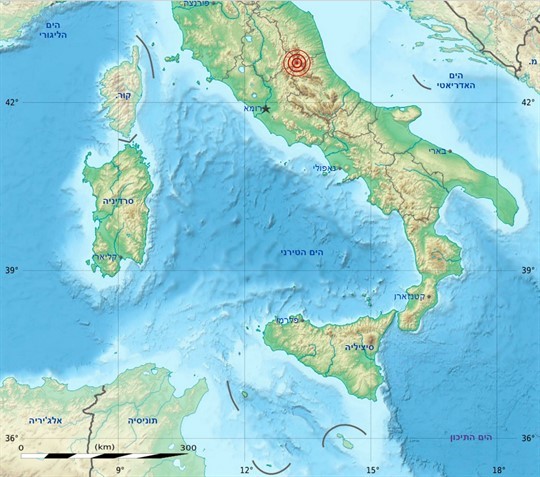
Figure 1: General location of the earthquake zone I,II in central Italy
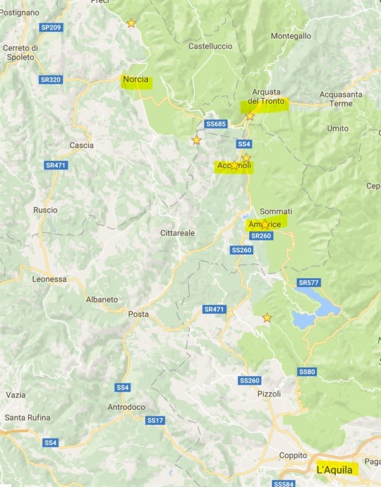
Figure 2: General location of the seismic zone I, II in central Italy
From a perusal of Figures 3-5 in the attached Appendix 1, several insights can be derived, the main of which are:
• Although the greatest damage in the sequence of events was in Amtriche due to earthquake I, the intensity of the ground vibrations felt there due to this earthquake, are lower than the ground vibrations felt in the same earthquake in the town of Norce, and than the ground vibrations felt in the town of Norce II.
• There is a significant difference in the spectral acceleration measured in Amtriche (Figure 3d) in the east-west direction (in red) compared to the acceleration in the north-south direction (in blue). When the values of the acceleration in the east-west direction are more than 50% higher than the acceleration of the Italian standard for this area..
• The peaks of the spectral accelerations in both tremors are in the range of low cycle times (0.2-0.4 seconds), and in resonance with cycle times suitable for low buildings on the local rocky ground.
• It can be seen that in the case before us there is a distinct dominance of the base oscillation in the east-west direction (marked in yellow in Figure 3b). The above is due to a "velocity pulse", which creates a destructive wave that is sometimes received at certain points near the fault line under certain conditions that affect the way the waves travel through the ground (explanation and references to the expansion at the end of the attached Appendix 1), and thus the great destruction in the Amtrich area, actually from an earthquake with intensity Less, relative to nearby places or to the tremors that occurred after it in the area, shows that a pulse in a certain direction can be a much more dominant and significant factor than the intensity of the tremor, its peak accelerations and displacements or the number of oscillation cycles.
In the following sections, the above phenomena will be demonstrated:
Examples of damage and methods of initial treatment and restoration:
The series of earthquakes that occurred in Italy between the dates 24/8/16 and 30/10/16 sowed great destruction in the areas where the earthquakes occurred, up to a distance of dozens of kilometers from the epicenter. In the patrols we conducted, damage to infrastructure and roads, bridges, and various types of buildings was documented. Below are several examples*.
A. Infrastructures, and road structures:
Most of the roads in the tremors area are narrow and winding. Some of them were blocked due to landslides, bridges that were damaged, and buildings that collapsed on the road. Two months have passed since the earthquake and it is clear that many rehabilitation efforts have been and are being invested primarily in opening the roads as a necessary condition for regulating access to the treatment and rehabilitation of the affected towns and continued functioning in the area. Many roads have sections with only one lane open, and one closed for renovation. Many bridges were damaged, some slightly and some more significantly, when the latter were closed, and with them, sometimes, the road. The damaged bridges are mainly the low ones, which have short cycle times. In bridges with medium and high intermediate spans, the vulnerabilities are mainly in travel due to the impact. Temporary bridges were placed in some of the places where the conditions allowed their construction. No damage was observed by us in the underground tunnels cut in the rock on all the roads in the area.
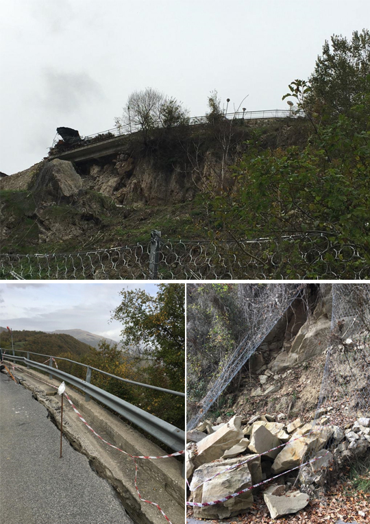
Photo 1 (above): Landslide under the road in the town of Pescara del Taranto (photo: Yaron Ofir)
Photo 2 (below right): landslide under the road in the town of Akumali (photo: Yaron Ofir)
Photo 3 (below left): Landslide on the access road to the town of Akumali (photo: Yaron Ofir)
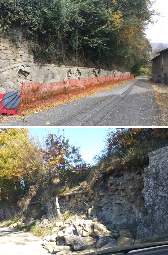
Photo 4 (above): A supporting wall that was damaged on the access road to the town of Akumali, 10/26/16
Photo: Yaron Ofir
Photo 5 (below): A damaged retaining wall near Norcha, 1/11/16
Photo: Alex Shohat
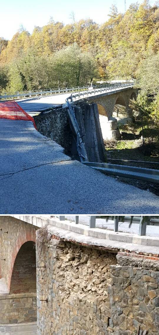
Photo 6a (top): View from the west of the approach road to an old arch bridge damaged by earthquake I on the southern access road to Amatrice. The bridge is blocked. A bypass was established, 10/26/16
Photo: Yaron Ofir
Photo 6b (below): Close-up from the south on the roadway of the damaged bridge, on the southern access road to Amatrice. It can be seen that the bridge commissioners, who were upgraded in the past with tread bars (a few), were not damaged, 10/26/16
Photo: Yaron Ofir
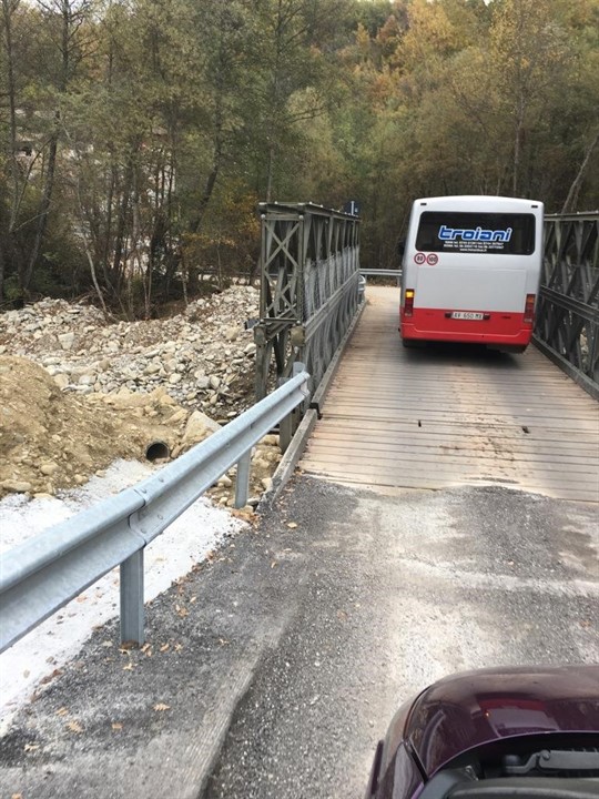
Photo 7: A temporary bridge erected after the earthquake, 26/10/16
Photo: Yaron Ofir
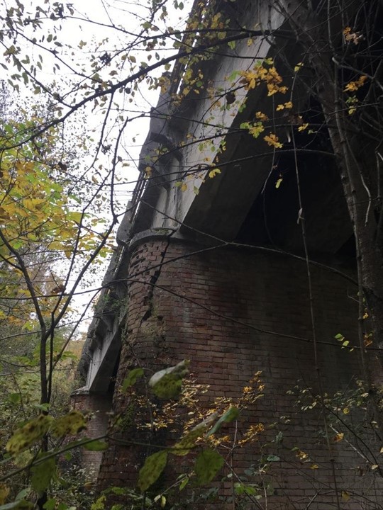
Photo 8: An intermediate commissary made of red bricks was damaged in an area that was not stressed by the beams of the bridge, 10/26/16
Photo: Yaron Ofir
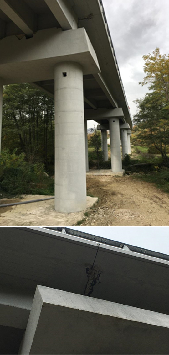
Photo a9 (top): New bridge on the SS4 highway from Rieti to Ascoli. The bridge commissioners were not harmed, 10/26/16
Photo: Yaron Ofir
Photo b9 (below): typical impact on the misch on its journey due to hitting a new bridge on the SS4 motorway from Rieti Ascoli 26/10/16
Photo: Yaron Ofir
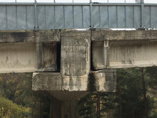
Photo 10: A typical damage to the misch in its journey due to impact, (in addition to the wear problems) on a long bridge on the SS685 road between Norce and Pescara del Toronto, 26/10/16
Photo: Yaron Ofir
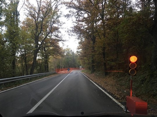
Photo 11: An automatic traffic light, one of many in the area, to transfer traffic to one lane to rehabilitate the partially collapsed road near Amtrich, 26/10/16
Photo: Yaron Ofir
B. Traditional buildings in Amtrica: Amtrica belongs to the province of Rieti and has been inhabited since prehistoric times. It is known that another severe earthquake previously destroyed the town in 1639. As of the occurrence of the first earthquake, the town had a population of about 2,700 people, and there was a variety of building types, including church buildings from the Middle Ages, scholastic residential buildings, industrial buildings, a number of other public buildings, a house Sefer, and traditional stainless steel buildings of 2-3 stories, built of red brick walls and wooden ceilings. A large part of the buildings of the latter type in the center of the town were destroyed (see marking in red rectangles in Figure 6). The destruction in the center of the town is due to a combination of several factors and mainly due to:
1. From the specific ground conditions and geometry in the area, and location relative to the focus, which enabled the formation of a strong velocity pulse that occurred in the area.
2. Matching the cycle times of the earthquake to the cycle times of the buildings in the center of the town, and this is in contrast to the survival of the clock tower and the church tower, which have higher cycle times than the other buildings in the area, and were therefore less affected by the amplification (see photos 12, 17).
3. The brittleness of the structural elements, and their lack of traction. The destruction was aggravated because in some of the buildings the wooden roof was replaced in the 60-80s of the last century with concrete ceilings. Also, at the time, a sealant with carcinogenic components was applied to the roofs, a fact that delays the evacuation and demolition of the buildings. (See photos 13, 14, 15).
The practical experience and knowledge gained by the Italian emergency forces in relatively frequent earthquakes and events such as these were reflected in the rapid establishment of the control and emergency center in Amtrich, which started working within 3 hours of the earthquake.
The order and control of the event is evident: many forces are working simultaneously, including a system that deals with taking care of the means of living for the residents of the area, dining rooms, living areas, transportation for students to alternative schools, escorting and monitoring citizens who return to the damaged houses, escorting research and inspection delegations, many police forces that prevent entry and looting For each area affected by the earthquake, reconstruction forces for infrastructure, care for the historical buildings (see picture 16), first aid for ordinary buildings that interfere with passage on the roads (see picture 18), and more. In Figure 6 you can see the updated control map of the emergency forces, on which the damaged areas, the organizing areas and more are marked.
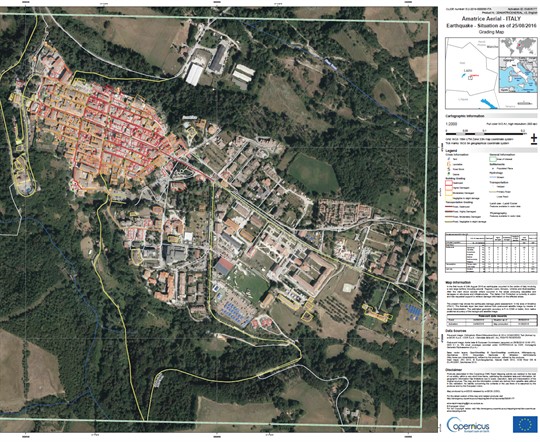
Figure 6: Part of the emergency organization map of Amatrice. Destroyed buildings and roads are marked in red, severe damage in orange, light damage in yellow. More organizing areas, tents, food distribution center, etc. are marked.
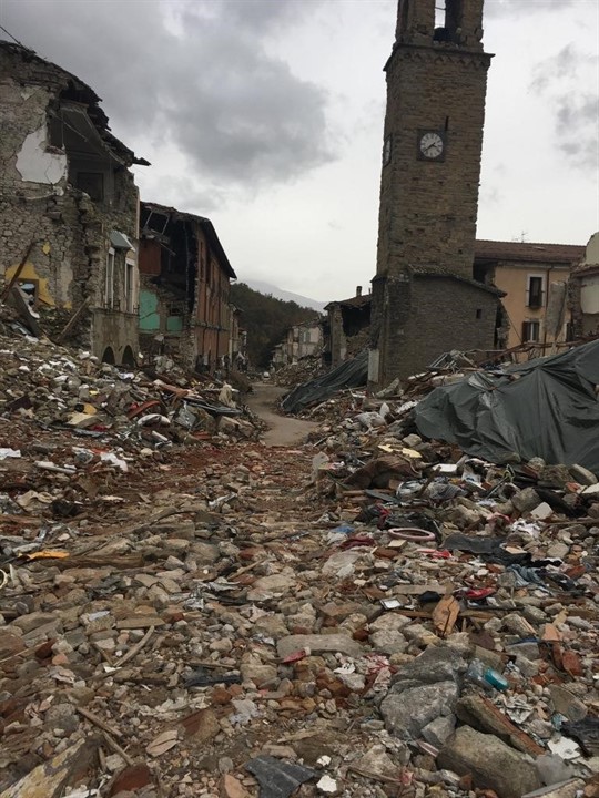
Photo 12: Destruction of buildings in the center of Amtrich. The clock tower survives despite being built from the same materials because of a higher cycle time, and different from the dominant time of the quake. Nylons cover some of the wreckage to protect equipment that has not yet been collected, 10/26/16.
Photo: Yaron Ofir
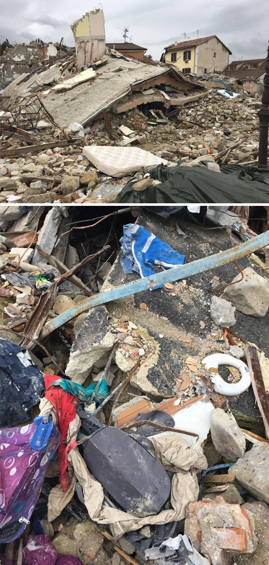
Photo a13 (above): Destruction of bare brick buildings in the center of Amtrich. You can
notice a concrete ceiling that aggravated the damage, 10/26/16
Photo: Yaron Ofir
Photo 13b (below): The tar coated concrete ceiling and round ziwn bars can be seen, 26/10/16.
Photo: Yaron Ofir
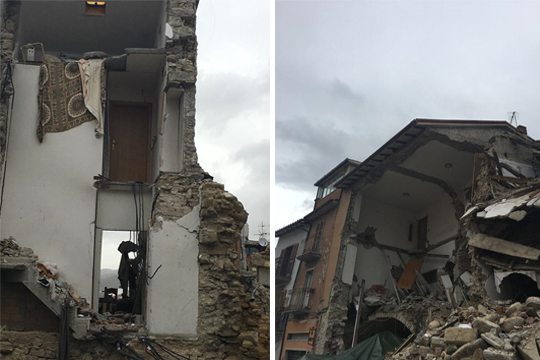
Photo 14 (left): Traditional brick buildings that have mostly collapsed in the center of Amtrich. You can see the concrete ceilings 26/10/16
Photo: Yaron Ofir
Photo 15 (right): Very old partially collapsed brick buildings in the center of Amatrice. to the structure
First ceiling by means of a stone vault and an upper ceiling that was cast at a later stage and remained hanging on the upper gable lug cast in concrete, 10/26/16
Photo: Yaron Ofir
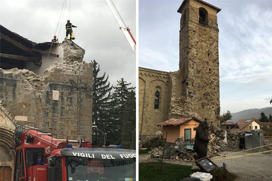
Photo 16 (left): Careful dismantling of the tiles, for the restoration of the 14th century church damaged by the earthquake in Amtrich, 26/10/16
Photo: Yaron Ofir
Photo 17 (right): Another tower, in a medieval church, which survived the earthquake in Amtrich, 26/10/16
Photo: Yaron Ofir
.png)
Photo a,b,c,d18: "First aid" wooden restoration for a building in danger of falling near the main entrance to the center of Amtrich. 26/10/16
Photo: Yaron Ofir
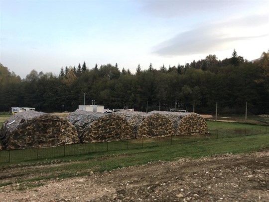
Photo 19: A tent complex for evacuees near Amatrice. The complexes are well equipped and seem to be ready for the cold winter. Scattered in the area are a number of camps as well as caravans set up on agricultural farms. 26/10/16
Photo: Yaron Ofir
C. Damages in other towns: Many towns in the area of the noise became ghost towns and were abandoned, some completely destroyed, and in some only a few buildings survived.
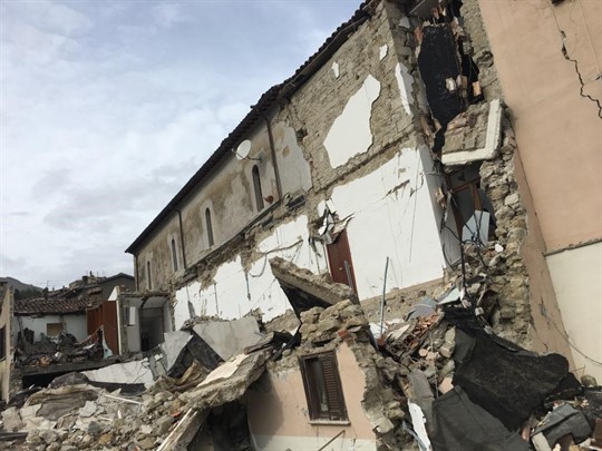
Photo 20: A partially destroyed house in Akumoli, where 4 residents were killed 10/26/16
Photo: Yaron Ofir
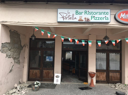
Photo 21: An abandoned pizzeria in Akumoli: food remains inside accompanied by a bad smell, and dishes left in their place exactly as they were placed on the eve of the earthquake, 10/26/16
Photo: Yaron Ofir
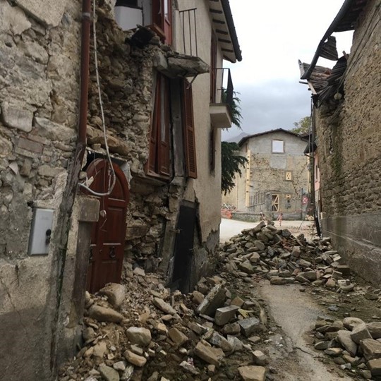
Photo 22: The center of the village of Restoli. The village is abandoned, like many of the villages in the area that were not mentioned in the media, 10/26/16
Photo: Yaron Ofir
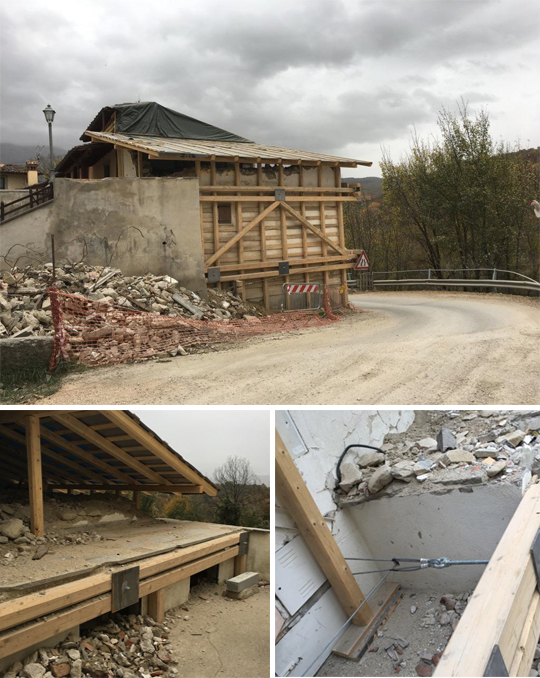
Photo 23a,b,c: The only house that was immediately upgraded in the village of Retrosi (Retrosi) with cables and logs, to ensure that it does not collapse on the eastern access road to Amatrice after the western access road to it was blocked by the earthquake.
26/10/16
Photo: Yaron Ofir
Photo 24a,b,c,: Upgrading a building in "first aid" in the center of the village of Capitignano, which is about 25 km from the epicenter, with wood and steel cables, to ensure that they do not collapse and block the road.
26/10/16
Photo: Yaron Ofir
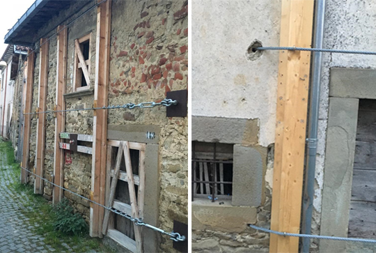
Photo 25a,b: Upgrading another building in the village of Capitignano, by wood and steel cables, which penetrate into the building and are locked
The same, 26/10/16
Photo: Yaron Ofir
.png)
Photo 24a,b,c,: Upgrading a building in "first aid" in the center of the village of Capitignano, which is about 25 km from the epicenter, with wood and steel cables, to ensure that they do not collapse and block the road.
26/10/16
Photo: Yaron Ofir
Derikha holds up and the building next to it that has not been upgraded is damaged and receives "first aid", 10/26/16
Photo: Yaron Ofir
Photo 27a,b: Buildings in the village of Capitignano, which were upgraded before the earthquake with walking poles (numbered), and were not damaged by the earthquake, 10/26/16
Photo: Yaron Ofir
d. Damages to concrete buildings: Unlike the media reports, many damages and destruction were also caused to modern reinforced concrete structures, including those with characteristics similar to buildings in our area (except for the walls of the buildings, which are made of bricks and not of concrete blocks or Itung). In a large part of the buildings in Amtricha, the concentrated damage in the dominant direction of the earthquake (east-west) stands out.
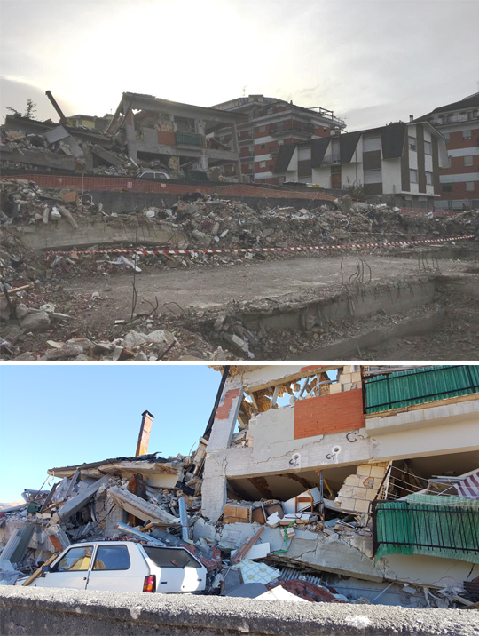
Photo 28: Examples of destruction and damage in skeletal residential buildings in Amtrich, 26/10/16
Photo: Yaron Ofir
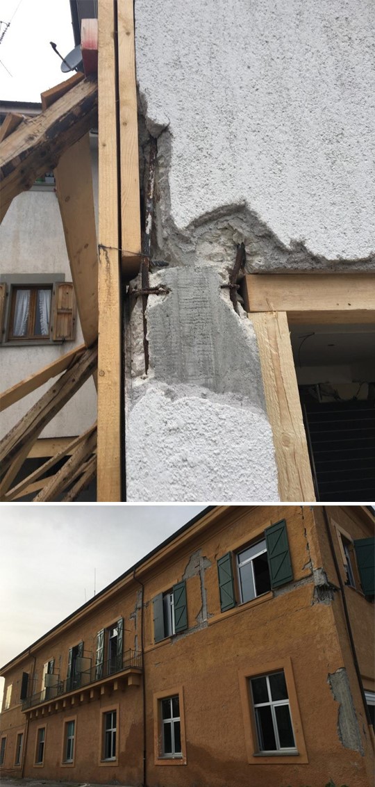
Photo 29a,b: Examples of node failures due to non-pulling details in skeletal residential buildings in Amtrich. In the lower picture, greater damage in the long direction: east-west, 26/10/16
Photo: Yaron Ofir
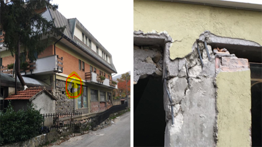
Photo 30a,b: Junction failure due to insufficiently dense hoops for shearing in the column, in a residential building in Shlod in Amtrich, 26/10/16
Photo: Yaron Ofir
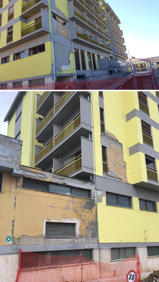
Photo 31 (above): A hotel in Amatrice where the damage on the southern and northern facades, evidence of the dominance of the earthquake in the east-west direction, 10/26/16
Photo: Yaron Ofir
Photo 32 (below): Damage due to the impact of the lower structure on the upper structure, 10/26/16
Photo: Yaron Ofir
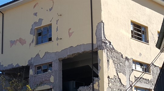
Photo 33: Concentrated damage on the lower floors in many buildings in the Amtrich area, apparently due to the speed pulse
26/10/16
Photo: Yaron Ofir
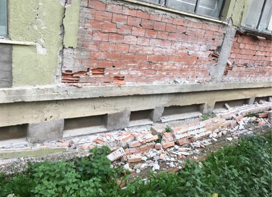
Photo 34: Short columns on the base floor that were not significantly damaged, probably due to symmetry, a sufficiently high tolerance or that a horizontal support was formed for the floor above them on one of the facades of the building.
26/10/16
Photo: Yaron Ofir
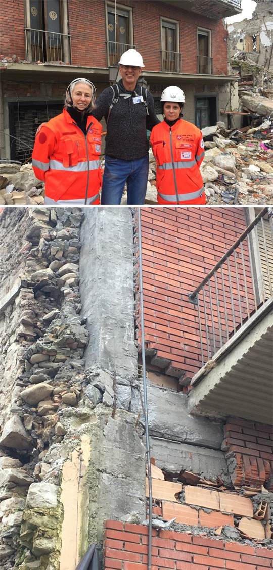
Photo 35a: A skeletal structure that did not collapse in the center of Amtrich, 26/10/16
Photo: Yaron Ofir
Photo 35b: A concrete column-beam junction that was damaged in the above structure, but its tolerance was sufficient to prevent it from collapsing
26/10/16
Photo: Yaron Ofir
God. Damages in prefabricated buildings and industrial buildings: Many prefabricated buildings have failed. As with the residential buildings in the town centers, these buildings also usually have low to medium cycle times. The main reasons for the failure are bad connection details. External walls that were not connected to the building properly - lack of topping over the pre-drilled panels to some of the building's ceilings, loose connection between the components The subjects to the ceilings. A lot of damage to the goods was recorded.
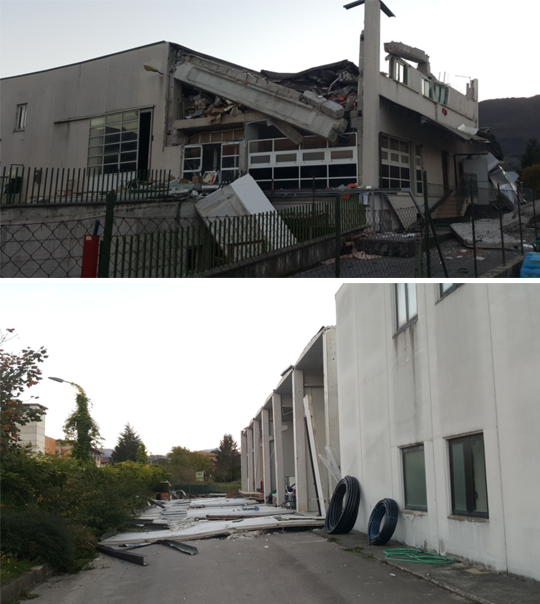
Photo 36: Failures in prefab buildings: prefab beams and the roof dropping (above), prefab front panels dropping (below)
01/11/16
Photo: Alex Shohat
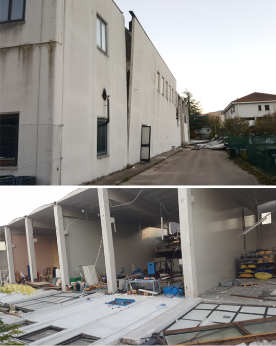
Photo 37: Failures in prefab industrial buildings: partial failure of the upper part of prefabricated wall panels (above), complete failure of panels (below), 01/11/16
Photo: Alex Shohat
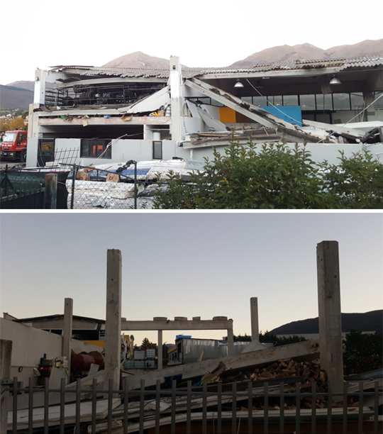
Photo 38: Failures in prefab industrial buildings: (above) the failure of roof prefab panels, due to lack of topping and sufficient connection details. (Below) Dropping of precast beams and beams, 01/11/16
Photo: Alex Shohat
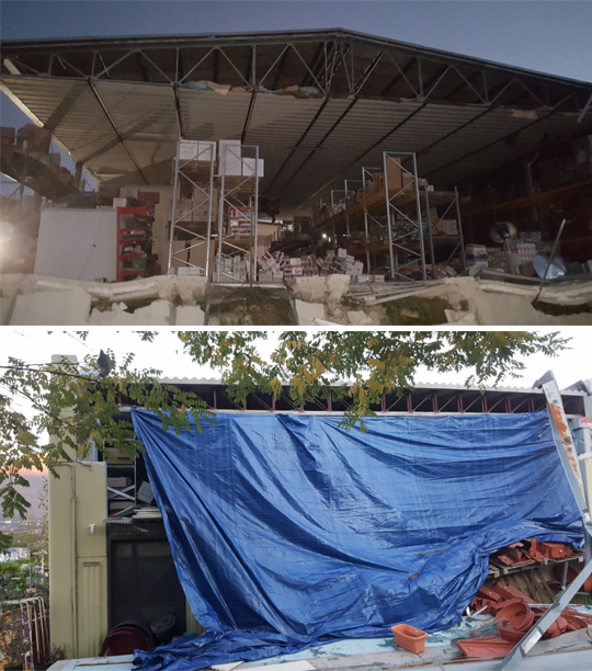
Photo 39: Failures in industrial storage buildings with a light roof made of steel trusses. (above) Structural damage to the exterior panels and heavy damage to the equipment on the shelves. (Below) Cover affected area Capricorn to keep goods inside. 01/11/16
Photo: Alex Shohat
Examples of upgrade bikes done in the area before the earthquake
A. Romelo School in Amtrica: A part of a school that contains classrooms is built in the shape of an "H" as can be seen in Figure 7. The parts marked in blue are parts that were upgraded in 2012 with an investment of about 600,000 euros. According to the information we have at this stage (site visit, excerpts from the press and unofficial words from Italian professionals) the upgrade included the application of FRP sheets as well as the construction of two flights of stairs, one for each wing as well as exterior renovation and the addition of a new roof. The two upgraded parts were damaged but did not collapse. The rest of the building, built of uncorroded brick walls, partially collapsed. It should be noted that the breakdown is currently under investigation and there is no established information on the matter.
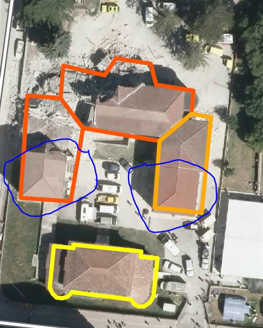
Figure 7: Aerial photograph of Romelo Primary School, from the Emergency Preparedness Map of Amtrich.
.png)
Photo 40 (above): View from the southwest, from inside the "H" on the new wing (on the right) and on the left the section that was not upgraded and partially collapsed, 10/26/16
Photo: Yaron OfirPhoto 41 (below): View from the northwest, of the new wing that includes an upgraded FRP column (on the right) and on the left the section that was not upgraded and partially collapsed, 10/26/16
Photo: Yaron Ofir
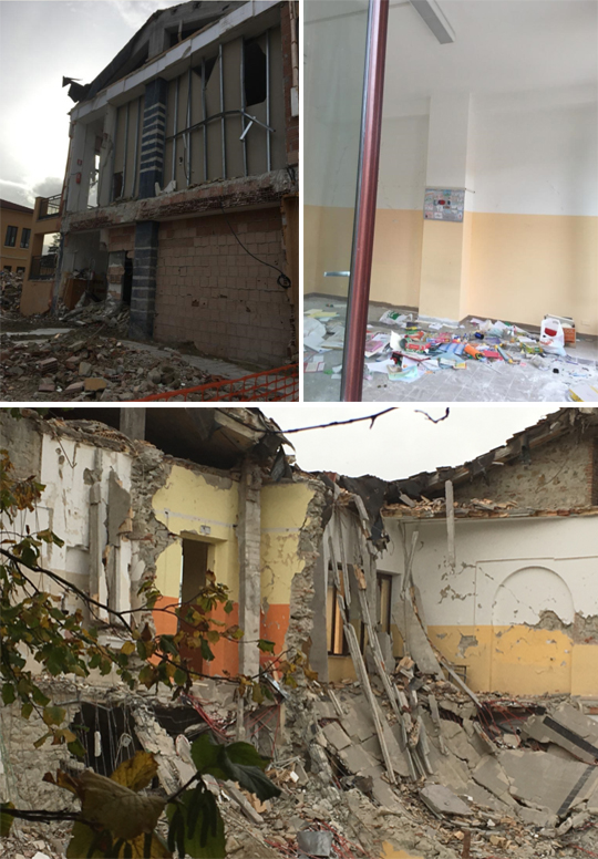
Photo 42 (top left): Close-up photo, on the FRP-wrapped column at the end of the new wing that did not collapse.
Photo 43 (top right): Close-up photo, on a column probably wrapped in FRP and coated with paint at the other end of the new wing that did not collapse.
Photo 44 (below): Close-up photograph from the north of the section that was not upgraded and partially collapsed.
B. Upgrade in steel diagonals
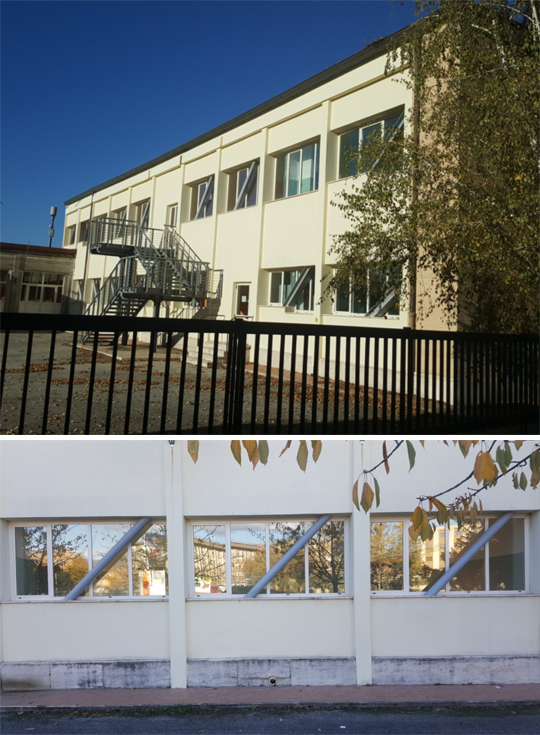
Photo 45: Upgrading the building of a Briati school, 1/11/16
Photo: Alex Shohat
Photo 46: Upgrading the building of a school in Briati, cracks due to the earthquake, or temperature differences
1) From comparing the basic earthquake data to the damages that occurred in this earthquake, it can be concluded that the intensity of the earthquake and the acceleration values are not necessarily the most influential parameters, and are not directly related to the damage. In contrast, the speed pulse (when it occurs) and the directionality of the vibration are parameters that greatly affect the level of damage.
2) Two months after the earthquake, most of the reconstruction operations are concentrated on upgrading roads and roads, buildings that obstruct traffic, and slow restoration of historical buildings. There is almost no touching of residences, with the exception of preventative care to prevent collapse. It should be noted that this was also the approach in previous earthquakes, when the city center of L'Aquila, which was severely damaged by an earthquake in 2009, has not yet been fully restored allowing a return to regular life.
3) You can learn from the Italians about initial upgrade modes for first aid. It should be noted that these "first aid" measures, even though they are very basic, seem to be very influential in some cases and help the structure to function better in additional tremors/aftershocks, as was evident from the last series of tremors.
4) It is possible to learn from the efficiency and professionalism of the Italians also in matters of organizing in an emergency.
5) Contrary to the seller, foundation pillars were observed in several buildings that were not damaged. The above can be explained either by their symmetrical distribution in the perimeter of the building, excess tolerance, or the existence of a horizontal support, which was not exposed to the eye at the ground floor level. Such a support may prevent relative displacement and the development of damage at the level of the foundation columns.
6) We found no evidence of damage to the foundation during the (limited) tour, and most of the damage was observed above ground level.
7).
8). When an upgrade project is currently carried out in a single building in Israel, considerable resources are usually invested in it. One of the most striking impressions of the tour is that if we prepare for an earthquake of a magnitude similar to that experienced in Italy, with the amount of resources invested in one project, it is possible to carry out more efficient and gentle upgrading operations in a larger number of buildings for the purpose of saving Haim, Z.A. The existing resources can be utilized in a much better way to deal with a significantly larger inventory of buildings than the one dealt with today.
9) Other effective ways to deal with upgrading a stone structure or brittle structures (such as "honey" concrete) are horizontal bracing and/or gluing of FRP sheets, or base insulation. Losing weight (mass) will also help a lot, if possible.
10) In the buildings documented in the tour, it is possible to notice many examples of buildings that "met" the "saving life" criterion which is mainly aimed at by the standard today. These buildings were abandoned and it is clear that compliance with this criterion does not allow continued residence in the damaged buildings. This issue should be brought up for public discussion and considered if it is not worth updating.
* Yaron Ofir, M.Sc, engineer and building inspector
** Alex Shochat, structural engineer
`
Link to the article: